
Pointing out locations is very important in today’s world. The North America Map Template offers the ability to pinpoint locations preferred by the user. The most unique feature about the North America Map Template is that it allows you to customize the map to fit your tastes and needs.
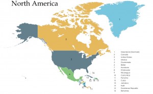
The North American Map Template can be used to create maps of any of the 50 American states or all of the 10 provinces of Canada, as well as generating individual maps for any American county if the need arises. It also features a template for the 48 Lower states in the US. It has flags and flag pointers that play a key role in pointing out locations or branches of businesses within a particular area. It is therefore quite easy to use the North American Map Template’s features to locate a specific area and review its details.
How to Use the North America Map Template
- You will need to download the North American Map Template from this page in order to use it.
- Search for and locate the Find box on the North American Map Template and type in the name of the place for which you want to create a map.
- Click OK when the dialog box appears. The map will then feature the place of your interest. Click at its center and select the place’s shape object.
- Locate the Drawing toolbar, which by default is at the bottom of the screen. Change the line to Black and the fill to No Fill.
- This will show only you that area’s map. It’s that simple!
Tips for Using the North America Map Template
- In order to add or remove icons using the mouse, move the mouse over to Tooltips and open the Info box.
- When using the template, iMapBuilder software can be used to edit region and area color or background and links.
- Lines, countries, area color, mouse effects and icons can be added to the map easily.
- The registered version of the North America Map Template removes unnecessary demo buttons and all watermarks from the map templates.
- You can easily import any of your images into the map. Extensions of images supported are JPG, PNG and GIF.
- Multiple areas can be grouped to form one custom region, such that on mouse-over effect they display the same color.
- The Category legend can be used to toggle between displaying and switching off objects on the map.
- The Click to Zoom feature can be enabled when using the template. Clicking on the map enlarges the selected area so that it displays finer details of that particular place of interest.
Locating places is very important to everyone. The North America Map Template makes using maps to pinpoint a region and its details quite easy – it is simplified and efficient for the user. The maps can be used to display all the states and counties in the US as well as all the Canadian provinces. The ability to be easily customized enables the users to satisfy their needs and provide them the efficient direction and guidance that they require.
Download: North America Map Template
Check this out while you wait!